 |
| PERU |
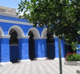
| District of Arequipa |
|
 |
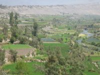
This region has a rough
topography which is characterized by heavy layers of volcanic
lava covering large areas of its inter-Andean sector. It has deep
canyons such as the ones formed by the Ocoña and Majes rivers.
Plateaus range in height from medium, such as La Joya, and
high-altitude ones such the Arrieros Pampa and those located in
the zones of Chivay, Huambo and Pichucolla. Volcanic cones are
seen emerging above the plateaus and forming snowfalls, such as
Misti, Chachani, Ampato, Mismi, Solimana and Coropuna. In
contrast with these heights, there are deep canyons, including
Majes, Colca, Sihuas and Ocoña, where important aspects of the
ecological evolution of this zone can be clearly observed.
In the Coast, small
plateaus and dunes represent characteristics of the desert of
Arequipa, such as the ones located in the Majes, Sihuas and La
Joya pampas, which are particularly beautiful and developed. From
a hydrographic point of view, the rivers draining its territory
belong mainly to the Pacific watershed. Some rivers belong to the
Amazon hydrographic system. Some of the region's main rivers are:
Ocoña, Yauca, Camaná and Quilca. The starting point of the
Amazon River, the longest river on Earth, is located in the
Arequipa region.
<- Back to the index