Puno is a region in
southeastern Peru. It is bordered by Bolivia on the east, the
Madre de Dios Region on the north, the Cusco and Arequipa regions
on the west, the Moquegua Region on the southwest, and the Tacna
Region on the south. Its capital is the city of Puno, which is
located on Lake Titicaca in the geographical region known as the
Altiplano or high sierra. Puno was the territory of the
Tiahuanacos (800 A.D. – 1200 A.D.) who were the highest
cultural expression of the Aymara people that established
themselves in what is today Peru and Bolivia. The Incas took over
these lands in the fifteenth century, and the Spanish, attracted
by the mining industry developed there, left an important
Colonial legacy throughout the entire area.
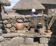
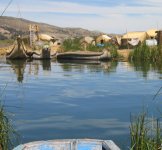
The city of Puno, 3,287
meter above sealevel,lies on the shores of Lake Titicaca, the
highest navigable lake in the world, is the folklore capital of
Peru and the site of the Feast of the Virgen de la Candelaria. In
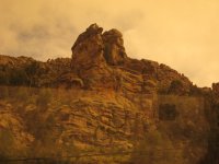
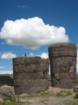
the outskirts, you can visit the spectacular Chullpas de
Sillustani, a complex of impressive burial towers built by the
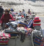
Kollas, Juli, famous for its beautiful Colonial churches, Lampa
with its vice royal church built between 1675 and 1685, Llachón,
a community that still maintains its centuries old customs and
cultural expressions, and Pucará, known for its pre-Inca pottery
and for the "toritos de Pucará" that the artisans of
today create from clay.
In 2013 I made a new
visit to the district, and have some new pictures here, and some
are included in the new pages. Hope you will enjoy the supplement
of pictures.
<- Back to the index